



You’ve got a 50-million-point cloud from a 500-image drone survey. Manual classification takes days. AI tools promise automation. Some deliver. Most don’t. Here’s what actually works.
In the past 18 months, Pix4D added machine learning classifiers to Pix4D Matic. Metashape 2.x integrated AI ground classification. DJI Terra reduced the workflow to a single button. But there’s a critical gap between what these tools claim and what they actually deliver — particularly accuracy. You will manually clean the results. AI saves time on the first pass, not the last mile.
This is what practitioners need to know about AI point cloud processing in 2026.
What “AI Classification” Actually Means
Before comparing tools, you need to separate the categories. “AI” covers four fundamentally different approaches:
Traditional physics-based filters — CloudCompare’s cloth simulation filter, statistical outlier removal, radius outlier removal. Not machine learning. These are mathematical operations on geometric properties: how your point relates to neighbors in 3D space. Fast, deterministic, no training required. Effective for noise removal, not class separation.
Machine learning classifiers — Random Forest in Metashape, linear discriminant analysis. Trained on labeled samples. The classifier learns decision boundaries from data you’ve already classified manually, then applies those boundaries to new data. Requires training data and you must know which features matter (geometry, color, elevation change). Success depends entirely on training sample quality.
Deep learning networks — PointNet, RandLA-Net, KPConv. Neural networks learn hierarchical features directly from point positions with no hand-engineered features. Benchmark performance on Semantic3D: 77–80% mean Intersection over Union (mIoU), meaning 20–23% of points are misclassified even on curated test datasets. Research-grade. Not operator-ready.
Integrated AI classifiers in commercial software — Pix4D, Metashape, DJI Terra. Pre-trained models, one-click operation. No manual training. Works out of the box for standard classes: ground, vegetation, buildings, roads. Moderate accuracy. Real speed savings on the first pass.
This distinction matters. A deep learning model at 77% mIoU looks good on paper. On a 50-million-point cloud, 11.5 million points are wrong — and you won’t catch all of them manually. An integrated classifier at 85% accuracy still leaves 7.5 million incorrect points, but it’s cleaner and runs in minutes.
The Tools That Actually Work
Here’s the current landscape for AI point cloud processing, ranked by practical adoption and real-world results.
| Tool | AI Method | Standard Classes | Ease of Use | Cost | Best For |
|---|---|---|---|---|---|
| Pix4D (Mapper/Matic) | Random Forest on geometry + color | Ground, Vegetation, Building, Road, Human-Made Object | One-click in Matic | ~$5,990 perpetual (subscription pricing varies — request quote) | Integrated photogrammetry-to-classification workflow |
| Metashape 2.x | Machine learning classifier | Ground, Vegetation, Building, Road, Car, Man-made | Click + optional training | $3,499 perpetual | Python API for custom classifiers; 3D model quality |
| DJI Terra | Ground classification + smart ML | Ground vs. non-ground + 3+ classes | Single button | $1,540/yr (Pro) | DJI Mavic/Air/Matrice users; simplicity |
| LP360 Drone (Drone Edition) | Deep learning (pre-trained) | Ground + utilities (power lines, poles, towers) | Moderate; utility-specific | $5,585 perpetual or $1,675/yr + AI add-on $5,280/yr | Transmission corridor mapping, utility asset detection |
| OpenPointClass | Random Forest / gradient boosted trees | Custom (19+ ASPRS classes) | Command-line (pctrain, pcclassify) | Free, open-source | Budget operators, custom class training |
| CloudCompare + 3DMASC Plugin | Random Forest (user-trained) | Custom, user-specified | Moderate; requires training | CloudCompare free; plugin free | Custom classification, visibility in 3D |
| Trimble RealWorks / TBC | Deep learning (customizable) | Custom, user-trainable | Complex; enterprise UI | Custom pricing (contact Trimble) | Enterprise Trimble workflows, large-scale asset management |
| ArcGIS Pro | RandLA-Net (Python API) | Custom (your choice) | Steep; requires PyTorch setup | $700 annual ArcGIS Creator license | GIS-first workflows, batch processing, research-grade accuracy |
The Integrated Tools: Pix4D, Metashape, DJI Terra
Pix4D Matic (2024+):
Easiest entry point for integrated AI point cloud processing. Import your cloud or process imagery directly in Matic. Run “AI Classification” from the menu. The pre-trained Random Forest model evaluates each point on geometry (curvature, elevation, normal direction) and color intensity. Ground, vegetation, buildings, roads — delivered out of the box. No training. Results in 5–15 minutes depending on cloud size.
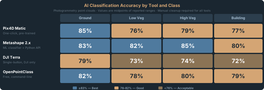
Accuracy on photogrammetry clouds: 82–88% for ground vs. non-ground separation. Vegetation vs. building separation drops to 75–80% — tall grass easily confused with small trees. Expect manual cleanup on building rooflines over trees and dense understory vegetation misclassified as ground.
Export as GeoTIFF orthomosaic or LAS with classification codes. No LAZ (compressed). A 50-million-point cloud exports significantly slower than competing platforms — a known friction point.
Metashape Professional 2.x:
Classification integrates directly into the photogrammetry pipeline. Process dense cloud → click “Classify Dense Cloud” → six classes in 5–10 minutes: Ground, High Vegetation, Building, Road Surface, Car, and Man-made Object.
The real advantage: Python API. Script the entire workflow — import, align, build dense cloud, classify, export LAZ. For teams processing 5+ projects monthly, automation savings compound. Metashape also lets you train custom classifiers by labeling a subset manually, then apply to the rest — useful for specialized classes like “power poles” or “parked vehicles.”
Accuracy: 80–86% across standard classes. Beats Pix4D on vegetation separation (85% vs. 78%), falls short on building edges.
DJI Terra:
Simplest interface for AI point cloud processing. DJI users (Mavic 3 Enterprise, Matrice 300) get ground classification automatically during orthomosaic generation. No separate step. No training. One checkbox.
Accuracy is lower — 75–82% — but the friction is zero. If you’re already in Terra and don’t need fine-grained classification, it’s sufficient for a first pass.
Cost: $1,540/year (Pro tier). Locked to DJI hardware.
OpenPointClass: The Free Alternative
Built by UAV4GEO — the same organization behind OpenDroneMap. Free, open-source, command-line tools (pctrain and pcclassify).
It uses Random Forest or gradient boosted trees — not neural networks. Supports 19+ ASPRS standard classes (ground, vegetation, buildings, cars, sidewalks, fences, poles, water, etc.). A 15-million-point cloud processes in under 2 minutes on a 4-core Intel i5 — CPU-native, no GPU required.
Accuracy: 78–84% on photogrammetry clouds, 83–87% on LiDAR. No vendor benchmarks — only real-world reports from the WebODM community showing consistent results across both data types.
Workflow:
- Train a model on labeled data:
pctrain --input labeled.las --output model.bin - Classify new data:
pcclassify --input raw.las --model model.bin --output classified.las - Review in CloudCompare, export as classified LAZ
The advantage: Built-in training via pctrain — label a subset of your data, train a model, apply to new projects. No TensorFlow, no PyTorch, no ML expertise beyond labeling points. CPU-native means it runs on any hardware — no NVIDIA GPU requirement.
For operators on tight budgets who can work from the command line, OpenPointClass delivers real accuracy without subscription or vendor lock-in.
What The Commercial Tools Get Right (And Wrong)
Pix4D’s integrated workflow: Process images, get a dense cloud, and classify in one ecosystem. No export/import friction. Results feed directly to orthomosaic generation and deliverables.
Metashape’s Python API: Script the entire pipeline including classification. Batch-process 10 datasets in one command. No commercial competitor does this cleanly.
DJI Terra’s simplicity: If your pipeline is DJI hardware + Terra, classification adds zero friction. Single checkbox during orthomosaic generation.
LP360’s utility focus: The only tool explicitly designed for power line and transmission tower detection. Purpose-built for corridor surveys. Other tools classify poles as “vertical objects.” LP360 distinguishes utility poles from streetlights and fences.
What they all get wrong:
No vendor publishes head-to-head accuracy comparisons. Marketing materials and case studies replace independent benchmarks. Semantic3D research shows the best deep learning models at 77–80% mIoU. Commercial tools exceed 77%, but not dramatically. Manual cleanup is unavoidable.
All struggle with mixed classes. A dense shrub taller than grass but shorter than a tree gets misclassified. Rooflines touching tree canopy confuse the classifier. Sloped terrain with vegetation creates ambiguity. Manual cleanup isn’t optional — it’s standard practice.
The Practical Workflow: From Raw Cloud to Deliverable
This is the actual process practitioners follow:
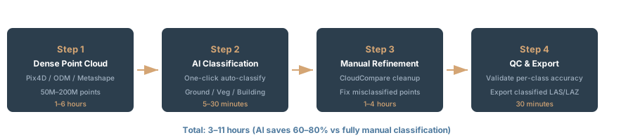
Step 1: Generate dense point cloud Process images through Pix4D, Metashape, or WebODM. Output: LAZ point cloud with geometry only, no classification.
Step 2: Automated classification Run the AI classifier in the same software or export to OpenPointClass:
- Pix4D: Click “AI Classification” in Matic
- Metashape: Chunk menu → “Classify Dense Cloud”
- DJI Terra: Check classification box during orthomosaic generation
- OpenPointClass: Load LAZ, select classes, click “Classify”
Time: 5–20 minutes depending on cloud size and hardware.
Step 3: Manual refinement Export classified cloud to CloudCompare with the classification color map. Manually reclassify errors:
- Rooflines misclassified as vegetation
- Understory shrubs misclassified as ground
- Tall grass misclassified as trees
- Building edges bleeding into adjacent classes
This takes 30% of total classification time. Every commercial operator performs this step.
Step 4: QC and export Final pass in CloudCompare for obvious gaps or errors. Export as classified LAZ with proper class codes (0=unclassified, 2=ground, 3=low vegetation, 4=medium vegetation, 5=high vegetation, 6=buildings, per LAS 1.4 spec).
Use the classified LAZ for:
- Digital terrain models (ground only)
- Vegetation volume calculations (vegetation classes)
- Building footprint extraction (building class)
- Infrastructure asset identification (utility poles, wires, roads)
Accuracy: What Actually Works
Research benchmarks on point cloud classification — Semantic3D, ScanNet, S3DIS datasets — show deep learning models at 77–80% mean Intersection over Union (mIoU). That means 20–23% of points are misclassified even on curated test data.
On a 50-million-point cloud, that’s 10–11.5 million incorrect points. You won’t catch all manually. Practical targets: aim for 85–90% accuracy after automated classification, accept 70–80% on edge cases and complex terrain.
What affects accuracy most:
Point cloud density. Sparse LiDAR (2–5 points/m²) is harder to classify than dense photogrammetry (50+ points/m²). More points provide more local geometry context, improving classification.
Color information. LiDAR-only: 75–80%. Photogrammetry with RGB: 82–88%. RGB channels help classifiers separate grass (green) from concrete (gray) from building materials.
Vegetation complexity. Single deciduous trees: 88%+ accuracy. Dense understory or mixed shrub/grass: 65–75%. Classifiers see geometry, not plant species.
Slope and terrain. Flat: 90%+. Steep slopes: 75–80%. Classifiers mistake slope angle for class boundaries.
Training data quality. Custom classifiers trained on mislabeled data perform worse than pre-trained models. Rigorous labeling is essential.
Hardware Requirements: RAM Beats GPU
GPU is necessary but not sufficient. RAM is the real bottleneck for AI point cloud processing.
Classification speed scales with RAM first, GPU second:
| Cloud Size | Recommended RAM | Recommended GPU | Processing Time |
|---|---|---|---|
| <20M points | 32 GB | RTX 3060 (12GB VRAM) | 3–5 min |
| 20–100M points | 64 GB | RTX 4070 (12GB VRAM) or RTX 6000 (24GB) | 8–15 min |
| 100–500M points | 128 GB | RTX 6000 (24GB) or A100 (40GB) | 20–45 min |
| >500M points | 256 GB | A100 (40GB) + multi-GPU | 60+ min |
GPU specifics:
NVIDIA CUDA is required for Pix4D and Metashape GPU acceleration as of April 2026. OpenPointClass is CPU-native and runs on any hardware — no GPU dependency.
RTX series (consumer): sufficient for datasets under 100M points. RTX 4090 is overkill unless you classify constantly.
RTX A-series (workstation): RTX 6000 Ada (48GB VRAM) worth the investment if you process 200M+ points regularly.
A100 / H100 (enterprise): Overkill for classification alone. Justified only if you’re training custom classifiers.
Storage: NVMe SSD is non-negotiable. Classification reads the entire cloud into GPU memory then into RAM. HDD bottlenecks I/O and masks actual hardware performance.
When to Skip Commercial Tools and Use Research Code
Deep learning models — PointNet, RandLA-Net, KPConv — are published with pre-trained weights available in open-source frameworks (PyTorch, TensorFlow). They outperform commercial tools on benchmarks.
But they require:
- PyTorch or TensorFlow installation
- GPU CUDA toolkit knowledge
- Custom inference scripts
- Model output debugging
- Edge case handling in production
ArcGIS Pro supports RandLA-Net via the deep learning Python API. If you’re an ArcGIS user with Python experience, that’s the closest path to research-grade accuracy in a commercial product. Otherwise: stick with one-click tools.
FAQ
Q: Can I classify drone photogrammetry point clouds the same as LiDAR data?
A: Yes, with 3–5% accuracy loss. Photogrammetry clouds are noisier (~3–5 cm standard deviation) than LiDAR (0.5–1.5 cm) but denser. Classifiers trained on LiDAR perform worse on photogrammetry due to noise. Pix4D, Metashape, and OpenPointClass models train on mixed data and handle both. Expect 3–5% lower accuracy on photogrammetry.
Q: Which tool separates vegetation from ground best?
A: Metashape (85%+) and Pix4D (82%+) in integrated mode. LP360 targets power line detection, not vegetation. For vegetation-specific work (low shrub vs. medium tree), Metashape’s custom training with a few hundred labeled points reaches 88%+. OpenPointClass: 80–82% on mixed vegetation.
Q: Is CloudCompare’s CSF filter AI?
A: No. Cloth Simulation Filter is deterministic physics simulation, not machine learning. A virtual cloth drapes over terrain, then pulls upward, revealing ground below and non-ground above. Effective for terrain plus vegetation, useless for vegetation plus buildings. Fast, free, no training. Use it for first-pass ground/non-ground splitting before ML classification.
Q: Can I batch-process multiple datasets automatically?
A: Metashape Python API has native support. Pix4D command-line is not straightforward. OpenPointClass has a CLI but minimal documentation. LP360 offers batch mode in Drone Edition. CloudCompare/3DMASC supports batch via CloudComPy (Python wrapper). Best option: Metashape for automation, manual runs for single projects.
Q: Do I actually need a GPU?
A: Yes. CPU-only on 50M points: 30–60 minutes. GPU (RTX 3060): 8–12 minutes. That 4–5x speed difference compounds across multiple projects per week. GPU is non-negotiable if classification is part of regular workflow.
Q: What if my point cloud has strange colors (bad white balance, overexposed)?
A: Integrated classifiers (Pix4D, Metashape, DJI Terra) use color alongside geometry. Poor color reduces accuracy by 3–5%. Pre-trained models trained on normal imagery perform worse on color anomalies. Metashape’s custom training on your data recovers some accuracy. For consistently bad color, geometry-only classification (CloudCompare CSF + 3DMASC Random Forest) may outperform color-dependent models.
Bottom Line
AI classification saves 60–80% of manual work on the first pass, but every deliverable requires manual cleanup on rooflines, vegetation edges, and complex terrain. Practical workflow: auto-classify in Pix4D or Metashape (5–15 minutes), refine in CloudCompare (30–60 minutes), export.
Best free option: OpenPointClass — no subscription, real accuracy (78–84%), CPU-native, command-line interface.
Best integrated option: Pix4D Matic or Metashape 2.x depending on existing workflow. One-click, moderate accuracy (82–87%), manual cleanup essential.
Best for utilities and corridors: LP360 Drone Edition — pre-trained on power line and tower detection. Expensive and purpose-built, worth it if that’s your core work.
Best for custom classes: Metashape with Python training — script training on labeled samples, batch-process dozens of projects with the same model every time.
Don’t chase deep learning research code without PyTorch expertise. Expect 77–87% accuracy depending on tool and terrain — 20–23% misclassification is the research benchmark. Plan 30–60 minutes of manual cleanup per dataset even with the best tools.
The efficiency gain is real. Time saved comes on the front end, not the back end.
Related Reading
For detailed software selection across the entire photogrammetry pipeline: Pix4D vs Metashape vs WebODM vs RealityCapture
For accuracy fundamentals: Drone Survey Accuracy: What Checkpoint RMSE Actually Means
For data source differences in classification: LiDAR vs Photogrammetry
For post-processing workflows with classified clouds: QGIS for Drone Data
For self-hosted processing: WebODM Local Installation
For flight planning that impacts classification inputs: GSD Calculator