


Updated October 2026: We corrected the WebODM steps (WebODM doesn’t auto-detect GCP targets; you tag each one by hand) and the Propeller AeroPoints description (onboard GNSS with PPK corrections). Doming advice now follows James and Robson (2014): oblique images are the main fix, not GCP placement. We also made the tier prices and accuracy figures match each other, updated the Emlid Reach RS2+ price and status, and said plainly which setups reach inch-level accuracy.
You’ve seen what ground control points do to a drone map. Published comparisons consistently show the same pattern when the same site is flown both ways: once with raw GPS, once with five GCPs measured with RTK or survey-grade equipment. The difference is stark. Raw GPS: ±10-16 feet (±3-5 m) horizontal error. Five well-distributed GCPs: ±3-6 inches (±8-15 cm) horizontal, ±4-8 inches (±10-20 cm) vertical. The accuracy leap is real. These figures track closely with the measured DJI Mini surveying accuracy benchmarks across the same three control tiers.
But there’s a catch most articles gloss over. Professional ground control means a surveyor and equipment. Trimble R10 base station: $15,000. Leica GS18 receiver: $12,000. Survey crew for a day: $1,000-2,000. If you’re shooting a real estate portfolio, a small farm, or a construction site for yourself, that cost doesn’t make sense.
The fix is simpler than you’d think: targets, accurate measurement, disciplined field procedure. No surveyor. No $15,000 RTK system. Be clear about what each budget buys, though. About $600 for a handheld GNSS receiver gets you consistent, documented control at the ±10-20 ft level, roughly the drone’s own GNSS accuracy. The inch-level results above need RTK-measured GCPs: about $2,900-5,600 for a budget RTK setup, or $200-300 a day to rent survey gear.
What You Actually Need: The 3 Core Pieces
DIY GCP networks have three moving parts.
Physical targets. Visible from 200+ feet altitude, unambiguous center, stable between measurement and flight.
Position measurement. Recording X, Y, Z coordinates with accuracy that matters. Phone GPS ($0, bad), handheld receiver ($100-600), inch-level budget RTK ($2,900-5,600), rented survey equipment ($200-500/day). Pick based on your accuracy needs.
Documentation and field discipline. Target ID, measurement method, equipment used, timestamp. This is what separates professional work from luck.
You’re cutting out the expensive parts of traditional surveying — crew, travel, site management — by doing them yourself. The only thing you’re really buying is measurement accuracy. Everything else is execution.
DIY Ground Control Point Targets for Drone Mapping: Build, Buy, or Improvise
Four options, from free to expensive.
Option 1: Homemade Targets ($0-50)
White plywood squares with black spray-painted X
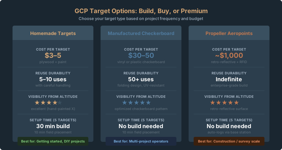
Get a 12x12 inch (30x30 cm) square of 3/4-inch plywood. Paint it all white (exterior paint, two coats). Once dry, use a stencil or tape to spray-paint a black X across the square, point-to-point corner-to-corner, 1.5-2 inches (4-5 cm) wide. The intersection of the X is your GCP center — unambiguous, visible from altitude, easy to mark in software.
Cost: $3-5 per target. Durability: reusable 5-10 times if you’re careful. Visibility from altitude: excellent. Can you leave it on site without it blowing away? No. Heavy wind will flip it or shift it. Secure it with sandbags or stakes, or pick it up immediately after flying.
Spray-painted X on pavement
If you’re surveying a parking lot or asphalt roadway, you can skip the plywood entirely. Use high-contrast spray paint (white or yellow) to paint a large X directly on the asphalt. Make the X thick enough that the center intersection is unambiguous — 6-8 inches (15-20 cm) wide. Mark the center with a small dot. Advantages: zero transport, zero setup, the target can’t blow away. Disadvantages: you’re painting client property, and you need to remove it afterward. For internal surveys on your own property, this is the fastest approach.
Cost: $2 per target. Durability: one use only. You’ll need to paint over it or let weather fade it.
Laminated paper or cardstock targets
Print a high-contrast checkerboard pattern on cardstock — 40x40 cm (16x16 inch) square, printed on heavy-weight paper, laminated with clear packing tape on both sides. Stake it to the ground or weight it with sandbags. It’ll survive light to moderate wind if secured. You can reuse it dozens of times.
Cost: $2-3 per target. Durability: 20-30 uses if laminated well. Visibility: good, though not as rugged as plywood.
5-gallon bucket lid
The orange or white plastic lid from a standard Home Depot or Lowes bucket ($1-2) is a legitimate GCP target. It’s 12 inches in diameter, rigid, highly visible from altitude, and practically free. Flip it upside down so the flat side faces up. Mark the center with a painted or taped X. A circle has no corners to sight on, so the painted X does all the work. Make it crisp, because you’ll click that center by hand in processing. Stack a few lids for extra weight — they nest flat for transport.
Cost: $1-2 per target if you buy lids separately, $0 if you already have buckets. Durability: reusable indefinitely. Visibility: excellent — the orange color is high contrast over grass, dirt, and pavement.
Start with 12x12 inch plywood squares. Cheap, durable, visible from 300-400 feet. The paint color doesn’t matter — what matters is the X intersection marking the exact center every time. Secure with sandbags or stakes so nothing shifts between measurement and flight.
Option 2: Manufactured Targets ($50-500)
Generic checkerboard targets (Amazon, eBay, surveying supplies)
Manufactured plastic or vinyl checkerboard targets, typically 50x50 cm (20x20 inch), come with folding stands or stake mounts. Brands like Neewer and generic Chinese suppliers sell them for $20-50 per target. They’re purpose-built: the checkerboard’s sharp central corner gives you an exact point to click, so tagging targets by hand in your processing software gets faster and more precise. (Automatic detection needs coded targets; see coded GCP targets.)
Upside: manufactured precision, folding design for transport, reusable 50+ times, looks professional on site. Downside: cost adds up fast ($200-300 for five targets), and you’re paying for features that don’t matter on a one-off project.
Cost per target: $30-50. Total for 5 targets: $150-250. Best for: operators flying multiple projects per year.
Generic targets with an Emlid receiver
Emlid (headquartered in Budapest), the manufacturer of the Reach RTK receiver (more on that below), doesn’t sell its own GCP targets. Operators on Emlid gear use generic targets, like the checkerboards above, and measure each center with a Reach receiver controlled from the Emlid Flow smartphone app over Bluetooth. Flow logs each point you measure and exports the list for your processing software.
Cost: the price of your generic targets plus a Reach receiver (the RS2+ lists at $2,699 on emlid.com). This only makes sense if you’re buying the Reach RTK system anyway.
Option 3: Propeller AeroPoints ($1,000 each, $5,000 per 5-pack)
This is the premium option. Propeller AeroPoints are smart GCPs. Each target has a built-in dual-frequency GNSS receiver: switch it on and it logs its position every 5 seconds while you fly, so you never measure the target separately. Afterwards the data uploads over Wi-Fi and is PPK-corrected through the Propeller Corrections Network. They cost $1,000 per unit, or $5,000 for a 5-pack. The corrections subscription is included for the first 12 months. After that it costs $1,000 a year per AeroPoint group unless you hold a Propeller Platform license (propelleraero.com).
Aeropoints only make sense if you’re operating at survey scale (50+ acre sites, recurring work, client paying premium prices). They’re overkill for consumer drone mapping.
Start simple, upgrade strategically
Start with homemade plywood targets. They cost almost nothing, take 30 minutes to build, and you know exactly how they work. Once you’re flying regularly and clients need tighter accuracy, step up to manufactured checkerboard targets ($30-50 each) and a Garmin GPSMAP 67i handheld receiver ($599.99). That’s $650-850 total. It covers work where a few metres of absolute error is acceptable, such as real estate, rough planning, and site documentation. Anything that needs inch-level elevations needs RTK.
Budget GCP Measurement: 4 Equipment Tiers for Drone Mapping
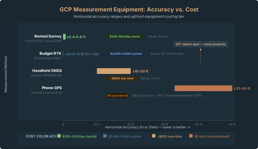
Your position measurement accuracy caps the accuracy you can achieve in processing. Bad measurements mean bad results. Four tiers, cheapest to most accurate.
Tier 1: Phone GPS ($0)
Use your smartphone’s built-in GPS to record latitude, longitude, and elevation at each GCP target center.
Accuracy achieved: ±33-50 feet (±10-15 m) horizontal, ±66-100+ feet (±20-30 m) vertical
This is bad. Worse than the drone’s onboard GPS in many cases. Under open sky on a good day, a smartphone is typically accurate to about 16 feet (4.9 m) (GPS.gov). Over a site with trees, buildings, and multipath errors bouncing signals off nearby structures, the 33-50 feet above is the realistic range, and it can be worse.
When to use phone GPS: You need relative accuracy within the site but don’t care about absolute geographic position. Your orthomosaic will be internally consistent but shifted relative to external data. Also works if you’re mapping a site where you already have external ground truth (known survey points, existing maps) to register against after processing.
How to measure with phone GPS: Download a free GNSS logging app like GPS Essentials (Android). On iOS, use a dedicated coordinate-logging app; Apple Maps shows your position but doesn’t log or average it. Position your phone directly over the target center. Let it sit for 30-60 seconds to average multiple measurements. Record the coordinates and take a photo of the target. That’s it.
Trade-off: Free. Accuracy ceiling: ±30-50 feet horizontal. Your orthomosaic won’t survive scrutiny if compared to survey data.
Tier 2: Handheld GNSS Receiver ($100-600)
Examples: Garmin GPSMAP 67i, Garmin GPSMAP 64csx, Magellan eXplorist
These purpose-built receivers include WAAS/SBAS corrections (Wide Area Augmentation System) that improve accuracy to ±10-20 feet (±3-6 m) horizontal. The antenna design and averaging algorithms are better than a smartphone. Most units run 6-12 hours on AA batteries. The Garmin GPSMAP 67i also has a barometric altimeter. It smooths short-term elevation changes, but it’s calibrated from GNSS and drifts with the weather, so it doesn’t make absolute elevations more accurate. (Note: The older GPSMAP 66s has been discontinued.)
Accuracy achieved: ±10-20 feet (±3-6 m) horizontal, ±16-33 feet (±5-10 m) vertical
This is workable for many applications. Real estate, low-accuracy agricultural surveys, volumetric calculations where ±10-15 feet is acceptable. Not acceptable for boundary work, precise construction stakeout, or legal surveys.
Cost: Garmin GPSMAP 67i approximately $599.99 (the older 66s is discontinued). 64csx approximately $200-300 used. Magellan units sometimes found on eBay for $100-150, but they’re discontinued and harder to use.
How to measure with handheld GNSS:
- Enable WAAS/SBAS corrections in the settings menu (usually labeled “SBAS” or “AUGMENTATION”).
- Position the antenna directly over the target center. Clear sky view — no trees, no building overhangs.
- Let it average for 30-60 seconds. The screen shows your accuracy estimate (usually “±X feet”) as it refines.
- Once accuracy stabilizes to your target (e.g., ±15 feet) for 5-10 seconds, take a waypoint.
- Photograph the target and note which waypoint number corresponds to it.
- Export the data via USB to your computer. Garmin units connect to Windows or Mac and let you export coordinates as CSV.
Trade-off: ~$600 one-time cost. ±10-20 feet accuracy. 6+ hours battery life. Rugged and waterproof. You’ll use this device for years.
This is the sweet spot for DIY work: roughly two to three times tighter than phone GPS in typical site conditions, and far more repeatable. Be clear on its limit. A handheld receiver’s ±10-20 ft is about the same as the drone’s own GNSS, so these GCPs give you a consistent, documented reference, not inch-level accuracy.
Tier 3: Budget RTK Receiver ($2,900-5,600)
Examples: Emlid Reach RS2+, SparkFun RTK, ArduSimple GNSS receiver
RTK (Real Time Kinematic) uses a base station and a rover receiver to achieve about an inch (centimeter-level) accuracy. The base station stays in a fixed location and transmits GNSS corrections over radio or cellular network to the rover. The rover uses those corrections to resolve carrier-phase ambiguities, achieving centimeter-level accuracy in real time.
Traditional survey-grade RTK systems cost $10,000-20,000 or more. Lower-cost products like Emlid Reach, SparkFun RTK and ArduSimple have brought a ready-to-use receiver down to a few thousand dollars. DIY board kits cost less, but you assemble and configure them yourself.
Accuracy achieved: ±0.8-1.2 inches (±2-3 cm) horizontal, ±1-2 inches (±3-5 cm) vertical
This is survey-grade. With this accuracy, your GCPs become ground truth. Processing software will achieve its theoretical limit of accuracy — ±2-4 inches (±5-10 cm) horizontal on most commercial-scale sites.
Cost breakdown:
- Emlid Reach RS2+ (configured as base station): $2,699 (emlid.com list price)
- Emlid Reach RS2+ (same unit, configured as rover): $2,699
- Cellular modem (for NTRIP corrections): $100-200
- Monthly NTRIP service (free through public providers or $50-100/month for commercial): varies
- Total: ~$5,500-5,600 for a two-receiver system
Note: the RS2+ is a single hardware model. You buy two identical units and configure one as the base and one as the rover; they’re not separate products. Emlid now marks the RS2+ as discontinued and points buyers to its newer Reach generation, though the RS2+ is still listed for sale. Check current models and prices before you buy.
Expensive for one project. Cheap when amortized. Fly 10 projects per year and RTK costs ~$550-560 per project, comparable to hiring a surveyor for a day.
Alternatives to reduce cost:
- Skip your own base: one receiver plus NTRIP: Use a single Reach RS2+ as the rover with corrections from an NTRIP caster, controlled from the Emlid Flow app on your phone over Bluetooth. Flow shows centimeter-level coordinates in real time, so you need neither a second receiver nor a separate rover display. That cuts the cost from ~$5,500 to ~$2,700-2,900.
- Use free NTRIP corrections: Many US state DOT real-time networks offer free NTRIP access after registration. Your own base can also send corrections over cellular or WiFi. The national CORS (Continuously Operating Reference Stations) network is managed by NOAA’s National Geodetic Survey (NGS); its data is mainly used for post-processing. Cost: $0 for corrections, you just need internet.
- Rent the equipment: Some surveying supply shops rent RTK base stations and rovers for $200-300 per day. For a one-off project, this is cheaper than buying.
How to measure with RTK:
- Set up the base station on a known benchmark or verified location (e.g., survey point on existing plans).
- Let the base station average for 15-20 minutes. This records precise location.
- Configure the rover to connect to corrections. For Emlid, use the Emlid Flow app.
- Position the rover antenna over the target center. The app displays your position as it refines. Wait for “RTK FIXED” — carrier-phase ambiguities resolved, accuracy at centimeter range.
- Once RTK FIXED appears, take the measurement. The app logs the coordinates.
- Export the data.
Trade-off: $2,900-5,600 upfront (or $200-300 rental per day). Centimeter accuracy. 30 minutes setup per project. Requires cellular or WiFi. ROI strong if flying multiple projects yearly.
RTK is worth it if you need consistent accuracy of about an inch (centimeter-level). The Emlid Reach line is well documented and has gone from niche survey gear to a real option for drone operators.
Tier 4: Rent Professional Survey Equipment ($200-500/day)
Call a local surveying supply company or equipment rental shop. You can rent a Trimble R10 or Leica GS18 for approximately $200-300 per day. Someone at the rental shop will show you how to use it (usually 15 minutes). Accuracy is sub-centimeter.
Accuracy achieved: ±0.4-0.8 inches (±1-2 cm) horizontal, ±0.8-1.2 inches (±2-3 cm) vertical
Cost: $200-500 per day plus gas to drive to the rental shop.
Trade-off: Best accuracy, minimal setup knowledge required, expensive for a single project but cheap for a day-long survey of multiple sites.
Only use this if you’re doing a large project where professional-grade accuracy is a contract requirement, or if you’re bundling it with other surveying work on the same day.
How Many GCPs and Where to Place Them
If you read the Crawl series, you’ve seen the theory. Here’s the practical version. Use the GCP Calculator to determine the right number of control points for your site size and accuracy requirements.
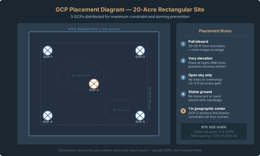
For sites under 50 acres, use 5-8 GCPs. Distribution matters more than count — spread them across the entire area, not clustered.
Placement rules:
- Inboard: Pull GCPs 30-50 feet (10-15 m) inward from the boundary. Boundary GCPs appear in only one or two images — weak constraint. Inboard targets appear in multiple overlapping photos — much stronger.
- Topographic variety: If your site has elevation change, place GCPs at highs and lows, not just at convenience locations, so the vertical is checked across the full range of the site. Don’t count on this to prevent the doming effect, the artificial vertical curvature of a domed or bowled surface. James & Robson (2014) traced doming to near-parallel, straight-down (nadir) imaging combined with the software mis-estimating radial lens distortion during self-calibration. The main remedy is adding oblique images (camera tilted off vertical) to the flight. Well-spread GCPs and checkpoints then pin the surface and show whether any dome remains.
- Clear sky: Each target needs unobstructed sky view. Trees, shadows, power lines all degrade GNSS accuracy. Clear sky adds 2-3 feet (0.6-1 m) accuracy versus shaded locations.
- Stable ground: Place targets on solid ground. Loose soil, sand, anything that shifts invalidates the control point. If you measure at 9 a.m. and wind shifts it 6 inches by 2 p.m., your measured coordinate no longer matches the imagery.
For a 20-30 acre site: 5 GCPs arranged in a rough grid — 4 pulled inboard from the corners, 1 in the center.
For a 30-50 acre site: 6-8 GCPs with wider spacing. Think of it as a grid: aim for one GCP per 5-10 acres, spaced no more than 1,000 feet (300 m) apart.
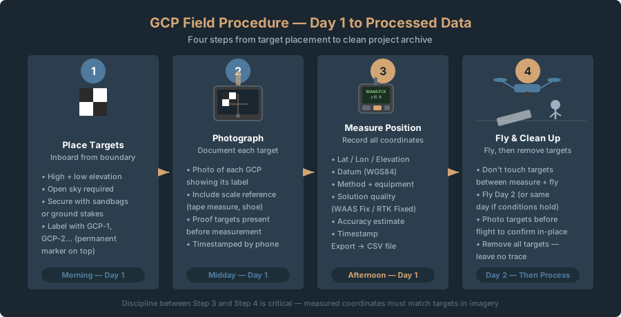
Field Procedure: Step-by-Step
Day 1: Set Up Targets and Measure
Morning: Place targets
Walk the site and identify locations using the placement rules above. Mark each with a flag or stake. Place your target at each location. Weigh down or stake homemade targets so they don’t shift in wind.
Midday: Photograph targets
Photograph each target with your smartphone. Include a measuring tape or known object (e.g., banana for scale) next to the target. This gives you visual proof the targets were present and unambiguous if coordinates are questioned later.
Afternoon: Measure positions
Use your chosen measurement method (handheld GNSS, RTK, etc.) to record coordinates at each target center. Record:
- Target ID (GCP-1, GCP-2, etc. — any consistent numbering)
- Latitude, longitude, elevation
- Horizontal datum and height type (ellipsoid or orthometric/geoid)
- Measurement method (Handheld GNSS, RTK, phone GPS, etc.)
- Equipment used (Garmin GPSMAP 67i, Emlid Reach RS2+, etc.)
- Solution quality (WAAS Fix, RTK Fixed, Autonomous, etc.)
- Date and time of measurement
- PDOP or horizontal accuracy estimate from your device
- Any notes (e.g., “target shifted by wind, re-measured 30 minutes later”)
If using a handheld receiver or RTK, export data to a CSV file (comma-separated values). This is the standard format for photogrammetry software.
Example CSV format:
GCP_ID,Latitude,Longitude,Elevation_m,Accuracy_m,Measurement_Time
GCP-1,40.12345,-105.67890,1542.50,0.05,2026-04-10-14:30
GCP-2,40.12456,-105.67812,1541.20,0.06,2026-04-10-14:45
GCP-3,40.12367,-105.67945,1543.80,0.05,2026-04-10-15:00
Day 2: Fly the Mission
Keep targets in place. Don’t touch them. Recorded coordinates must match targets in imagery or processing fails.
Fly following Crawl parameters: altitude for your desired GSD, 70-80% forward overlap, 60% side overlap. Targets don’t require special flight planning — just points that appear in imagery.
After Flight: Clean Up and Process
Remove all targets (leave no trace). Take them home or store them.
Transfer your imagery and your GCP CSV file to your processing software. See Walk 8: WebODM vs Pix4D for Consumer Drone Data.
In WebODM (it does not detect targets automatically; you tag every one):
- Set 2-3 measured targets aside as checkpoints and leave them out of the GCP file, so you can validate the result afterwards.
- WebODM Lightning: open the GCP Interface. It’s a Lightning feature: you need at least 1,800 credits bought within a year, or a monthly plan. Import your coordinate CSV (GCP label, X/Y or lon/lat, Z, plus the EPSG code). Then select each GCP, click Tag, and click the target center in at least 3 images; 8-12 is ideal. If your images are georeferenced, WebODM sorts them by distance from each GCP, but you still do the tagging.
- Self-hosted WebODM: open GCP Interface from the main menu (the POSM GCPi plugin, which ships with WebODM). Load your target coordinates and images, tag each target center in every image where it appears, and export
gcp_list.txt. Then upload that file with the images when you create the task. The first line is the projection (for exampleEPSG:32613orWGS84 UTM 13N). Each line after that is one sighting of a target in one image, in the formatgeo_x geo_y geo_z im_x im_y image_name [gcp_name], whereim_x im_yis the target center’s pixel position in that image. - Run processing, then compare the model against your withheld checkpoints.
In Pix4D:
- Import images.
- Open the GCP/MTP Manager.
- Import your CSV, checking the coordinate system and column order.
- Manually mark each GCP: at least 2 images, ideally 3 or more.
- Set checkpoint designations.
- Process.
Common DIY GCP Mistakes (And How to Avoid Them)
Measuring under tree canopy or in shadows. GNSS accuracy collapses with partial sky coverage. Your measured coordinate is wrong, the entire model skews. Always measure in open sky. If a target is inherently shaded (e.g., only flat spot on a hillside is under a tree), move it to the nearest sunny spot or remeasure multiple times and average.
Not labeling targets in the field. You have five plywood squares but no numbering system painted on them. Later, you can’t figure out which square in photos is GCP-1 versus GCP-3. Label every target with permanent marker visible on top. Photograph each numbered target before flying.
Antenna height error. If using RTK, the rover antenna has physical height above ground. Measure antenna height and subtract it from GNSS elevation. Measure 1,542.5 m with 2-meter antenna height, ground elevation is 1,540.5 m. Get this wrong by a foot, vertical error corrupts the entire model. Measure antenna height every project. Same antenna, but weather and transport shift equipment.
Expecting GCP placement to cure doming. Doming (artificial vertical curvature) comes from flying only parallel, straight-down passes and letting the software self-calibrate the lens. With near-parallel images it mis-estimates radial distortion, and the surface bends (James & Robson 2014). Spreading GCPs across highs and lows checks the vertical across the site, but it isn’t the cure. Add oblique images to the flight, which cut dome error by one to two orders of magnitude in James & Robson’s simulations, and keep a checkpoint near the center to catch any dome that remains.
Targets shifting between measurement and flight. You measure a GCP, fly 2 hours later, and find it’s been kicked or shifted by wind. Measured coordinate no longer matches imagery. Software can’t match the point to the target, and you lose that GCP or introduce error. Secure every target with sandbags, stakes, or caps. Photograph 10 minutes before flying to confirm targets are in place.
Mixing measurement sources for elevation. Barometric altimeters in consumer drones provide relative reference, not absolute accuracy. Some operators measure lat/lon with RTK but estimate elevation from the drone sensor. This introduces error. Measure all three coordinates (lat, lon, elevation) with the same equipment. Never mix sources.
Cost Breakdown: Real Numbers
Here’s what a DIY GCP campaign costs, broken down by accuracy tier.
Budget Option: Handheld GNSS + Homemade Targets
- 5 plywood targets with paint: $15
- Garmin GPSMAP 67i handheld receiver: $599.99
- Sandbags or stakes to secure targets: $10
- CSV file export software (free): $0
Total: ~$625
Accuracy: ±10-20 feet (±3-6 m) horizontal
Best for: Real estate, agricultural surveys, rough volumetrics, anywhere ±15 feet horizontal is acceptable. That’s about the drone’s own GNSS accuracy, so what you’re buying is a consistent, documented reference, not inch-level control.
Mid-Tier Option: RTK Receiver (Cellular) + Manufactured Targets
- 5 manufactured checkerboard targets ($35 each): $175
- Emlid Reach RS2+ (single receiver on NTRIP): $2,699
- iPhone or Android with Emlid Flow app (you have this): $0
- Cellular plan for NTRIP corrections ($50/month, split across 3 projects): $50
- Sandbags / stakes: $10
Total: $2,934 first-time, $60 per project thereafter
Accuracy: ±0.8-1.2 inches (±2-3 cm) horizontal
Best for: Professional work, engineering projects, boundary surveys, construction stakeout, anything where sub-foot accuracy is contractual. If you’re flying 10+ projects per year, cost amortizes to ~$350 per project.
One-Off Professional Option: Rent Survey Equipment
- Daily rental of Trimble R10 or Leica GS18: $250
- 5 manufactured targets: $175
- Gas, travel: $30
Total: $455 per project
Accuracy: ±0.4-0.8 inches (±1-2 cm) horizontal
Best for: Single large project where client pays for precision, or a day where you’re surveying multiple sites and can amortize rental cost.
Legal note. GCPs push your accuracy into territory that may trigger state surveying license laws. A georeferenced orthomosaic with 4-12 inch accuracy is “capable of measurement” under the 4th Circuit’s 2024 test — and delivering it commercially without a Professional Land Surveyor’s oversight is prohibited in states like North Carolina, Oregon, and Colorado. The GCP skills you’re learning here are legitimate and valuable — but the business model matters. Work under a PLS for client-facing deliverables. See Crawl 2: Where the Legal Lines Are.
You don’t need a surveyor to set up GCPs that meaningfully improve accuracy. Homemade targets cost $15-50, a handheld GNSS receiver costs ~$600, and disciplined field procedure takes a weekend to master.
Start with Garmin GPSMAP 67i + plywood targets. Set up 5-8 distributed across your site, measure with WAAS corrections, and tag them in WebODM. Expect ±10-20 feet (3-6 m). That’s roughly what the drone’s own GNSS gives, but now you have a consistent, documented reference you can check and repeat. It’s fine for real estate and rough planning, not for construction or anything measured in inches.
Upgrade to RTK when accuracy tightens or project volume rises. RTK-measured GCPs are what get a map to the ±3-6 inch range. Budget RTK like Emlid Reach measures the GCPs themselves to about an inch (±2-3 cm) and gives you professional credibility. System amortizes quickly over multiple projects.
Discipline is what separates consistent work from luck. Measure correctly, label clearly, secure targets, document everything. That part costs nothing. And it’s entirely in your control.
References
Research and standards cited in this article.
- James, M. R., & Robson, S. (2014). Mitigating systematic error in topographic models derived from UAV and ground-based image networks. Earth Surface Processes and Landforms, 39(10), 1413–1420. doi:10.1002/esp.3609